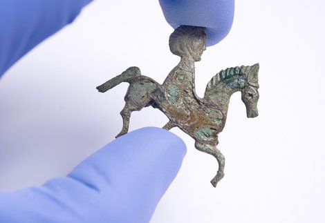
Amazing Finds gallery
Arbeia, South Shields Roman Fort
Managed by North East Museums on behalf of South Tyneside Council
A history of Arbeia, South Shields Roman Fort from 3000 BC to present day.

Overlooking the mouth of the River Tyne, Arbeia, South Shields Roman Fort guarded the main sea route to Hadrian’s Wall. It was a key garrison and military supply base to other forts along the Wall. Arbeia is an important part of the history of Roman Britain and is a UNESCO World Heritage site.
Hadrian’s Wall is the most impressive survival of the frontier works which marked the limits of the Roman Empire. Although South Shields fort was not actually on the line of the Wall it was an essential part of the frontier system. It controlled the port on the riverside, where most of the traffic passed between Hadrian’s Wall and the south.
People had lived on the site many centuries before the Romans arrived. It’s thought that the earliest settlers date from about 3000–4000 BC. An Iron Age farmstead dating to 300 BC has been excavated.
By the early second century a timber fort was built somewhere in this area. We know this because remains of the civilian settlement associated with the timber fort were found underneath the stone fort that can be seen today.
This fort was in place before Hadrian’s Wall was built. It’s likely that the fort was rebuilt or repaired at the time of the building of the Wall, as there was a second period of occupation, which included a training ground.
The building of Hadrian’s Wall, the eastern end of which is at Wallsend, approximately six kilometres upriver from South Shields, began in AD 122. After less than 20 years, it was abandoned. Around 142 AD the Antonine Wall was built between the Forth and the Clyde in Scotland, approximately 161km north of Hadrian’s Wall. This meant that South Shields probably became less important, and its garrison was likely reduced in size or even entirely removed.
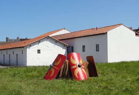
Due to shifting priorities Hadrian’s Wall was reoccupied in about AD 158. In around AD 163 a fort was built at South Shields, this time in stone. It covered an area of 1.67 hectares and was home to a unit of 480 soldiers and 120 cavalry soldiers.
Two barracks, each housing a cavalry troop of 30 men, have been excavated but are not visible on the site. Towards the end of the second century, the garrison seems to have reduced in numbers.
Between AD 205-7, most of the buildings were demolished and replaced by 13 stone granaries. The south wall of the fort was demolished, and a new wall was built farther to the south, increasing the size of the fort to 2.1 hectares. The southern part of the fort was separated from the granaries by a large wall and a headquarters building. South of the dividing wall was accommodation for the military unit that garrisoned the fort, which at the time was the Fifth Cohort of Gauls (Cohors V Gallorum).
The fort was now a supply base. It held grain and other supplies for the campaign of emperor Septimius Severus in Scotland between AD 208-10.
Baggage sealings made of lead and belonging to the Imperial household have been found at South Shields, suggesting that the emperor and his family were based at the fort for a time.
During the Scottish campaigns, the dividing wall was demolished, and a further seven granaries were built. A little later, a new headquarters building was added.
After the death of Septimius Severus at York in AD 211, the Romans left Scotland.
In AD 222-235 the accommodation for the garrison was entirely rebuilt and the supply base served Hadrian’s Wall and the forts in its hinterland.
Farming around the forts did not produce enough grain to meet all the needs of the garrisons and additional supplies were brought in by sea from the south of England and perhaps from the Continent.

In the late third or early fourth century the fort was attacked and burned down. During the rebuilding, the eight southern granaries were made into barracks. Two further barracks were built to the south of the converted granaries.
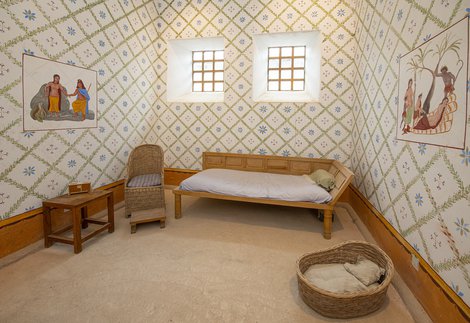
The southern corner of the fort was the site of a large courtyard house, which was probably the residence of the Commanding Officer. There were formal dining rooms for use in the summer and winter, private quarters and a set of baths.
A new headquarters building was built on the site of the headquarters of the original fort, restoring the use of the old cross hall, which had previously been converted into a granary.
The fort was divided into two areas, a supply base to the north and accommodation for the garrison to the south. The southern area was arranged around two streets, crossing at right angles. This was the latest fashion in Roman fort design.
This was the last overall rebuilding of the fort, and it probably marks the arrival of a new garrison, a unit of Tigris Boatmen (numerus barcariorum Tigrisiensium) from what is now modern Iraq. It was given the name Arbeia, meaning the ‘place of the Arabs.’ This replaced its earlier name, which was likely to be Lugudunum.
The unit remained in the garrison until the end of Roman rule in Britain.
Throughout the fourth century, minor alterations were made to the buildings which suggest a decline in living standards. For example, the heating systems in the large courtyard house were out of use, and at least one of the dining rooms was abandoned.
Victorian excavators found a table altar and the remains of a building, possibly a late Roman church in the courtyard of the headquarters building.
Although Roman rule in Britain had come to an end by the early years of the fifth century, the occupation of the fort continued. The granary north of the headquarters building was demolished and later, gravel was quarried from a nearby street.
The unsettled conditions in the early fifth century are demonstrated by the digging of a pit in the centre of the courtyard house that contained the bones of two youths with weapon cuts on their skulls.
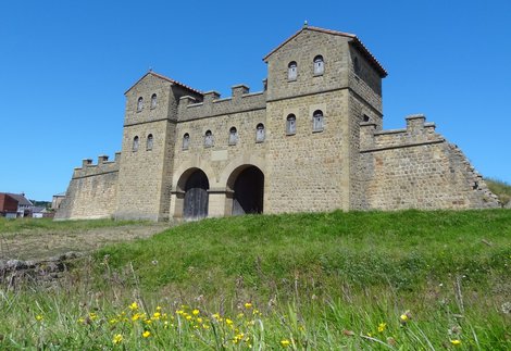
The west gate went out of use in the early fifth century and a large ditch was dug in front of it. The gate, although partially ruined was eventually restored. One of its arched carriageways was replaced by a timber entry.
In the fifth century, the fort was probably a stronghold controlling the surrounding countryside. When the Anglo-Saxons arrived, the site might have become property of the Royal House.
In the early seventh century, it was recorded as the place of birth of Oswin, King of Deira, who was killed in AD 651.
Objects dating between the sixth and ninth centuries show that it remained in use well into the Anglo-Saxon period. The fort may have been deserted in the ninth century, probably because of Viking raids.
By the 11th or 12th century the land that the fort sat on became property of the Cathedral of Durham and remained in their possession until 1875. It was all open farmlands.
In 1875, when the land was made available for housing, all that could be seen of the fort was the line of the west rampart.
Before building could start, antiquarians wrote letters to local newspapers to get public support for excavating the area before the Roman remains were lost. A committee, including the region’s leading archaeologists, was formed and it raised money to explore the site. This was only the second time that a large-scale excavation had been undertaken on a fort in northern Britain.
Due to the level of public interest in the Roman remains, the council took over some of the land and a ‘Roman Remains Park’ was created.
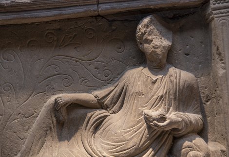
As the house building progressed beyond the site of the fort, many more discoveries were made, with the most spectacular findings being the tombstones of Regina and Victor.

Further excavations by Ian Richmond in 1949-50 recovered the history of the fort in outline. The museum opened in 1953, which led to the founding of the South Shields Archaeological and Historical Society. Over the next decade, the Society carried out several important excavations and in 1966-67 it took part in work directed by the late John Gillam of the University of Newcastle upon Tyne.
It was at this time that the council wanted to make the most of the fort and took the opportunity to demolish the housing built 90 years earlier to make a better visitor attraction. This was the first stage in the clearance of the structures built over the fort site itself which ended in the creation of a new Roman fort park. In 1975, the fort became responsibility of Tyne & Wear Museums, which began a programme of excavations, redisplay of the museum and the reconstruction of some parts of the fort.
Arbeia has two galleries. Set in Stone looks at the buildings on the site themselves, as well as religion and Roman death and burial practices. Amazing Finds looks at the objects left behind by the people living in the fort and what they can tell us about life here.
The fort also features striking reconstructions of the west gate, a barrack and part of a late Roman courtyard house.
A large part of the site has been excavated. Visitors can explore two headquarters buildings, two gateways, several granaries, granaries converted into barracks, two angle towers, a tile kiln, a water settling tank, a latrine and a building of unknown use.
Enjoyed reading about the history of Arbeia, South Shields Roman Fort? Why not join The Arbeia Society? You'll get access to a range of benefits, as well as supporting the fort. Find out more about the The Arbeia Society.